Sudden deactivation of the Madden-Julian Oscillation


Sudden deactivation of the Madden-Julian Oscillation

Mónica Minjares | Centre de Recerca Matemàtica

Álvaro Corral | Centre de Recerca Matemàtica

INTRODUCTION

As Randall [1] explains, in recent years atmospheric science has been “struggling to understand a very large and powerful tropical weather system called the Madden-Julian oscillation, or MJO. The MJO occurs mainly over the remote tropical oceans and was not discovered until the early 1970s. It strongly influences precipitation over southern Asia and northern Australia, affecting the lives of literally billions of people. It is also believed to influence the timing and intensity of El Niños. Despite its importance, the MJO is perhaps the last type of weather system for which the basic physical mechanisms are not well understood.” Following Hottovy [2], 10 years after Randall, one can state that nowadays “there is a lot of hypotheses about basic physical mechanisms of the MJO but not a consensus on them.”

The MJO constitutes the principal mode of variability in the tropical weather on sub-seasonal time scales (this goes from two weeks to approximately three months) and not only has a strong influence in the tropics but it also affects higher latitudes through teleconnection patterns [3]. The MJO is an atmospheric structure that, when it is active, tends to move eastward with an average speed of about 5 m/s. It is characterized by a region of strong convection with precipitation and upward motion, and ahead (to the east) and behind (to the west) there are regions of suppressed convection with dry conditions.

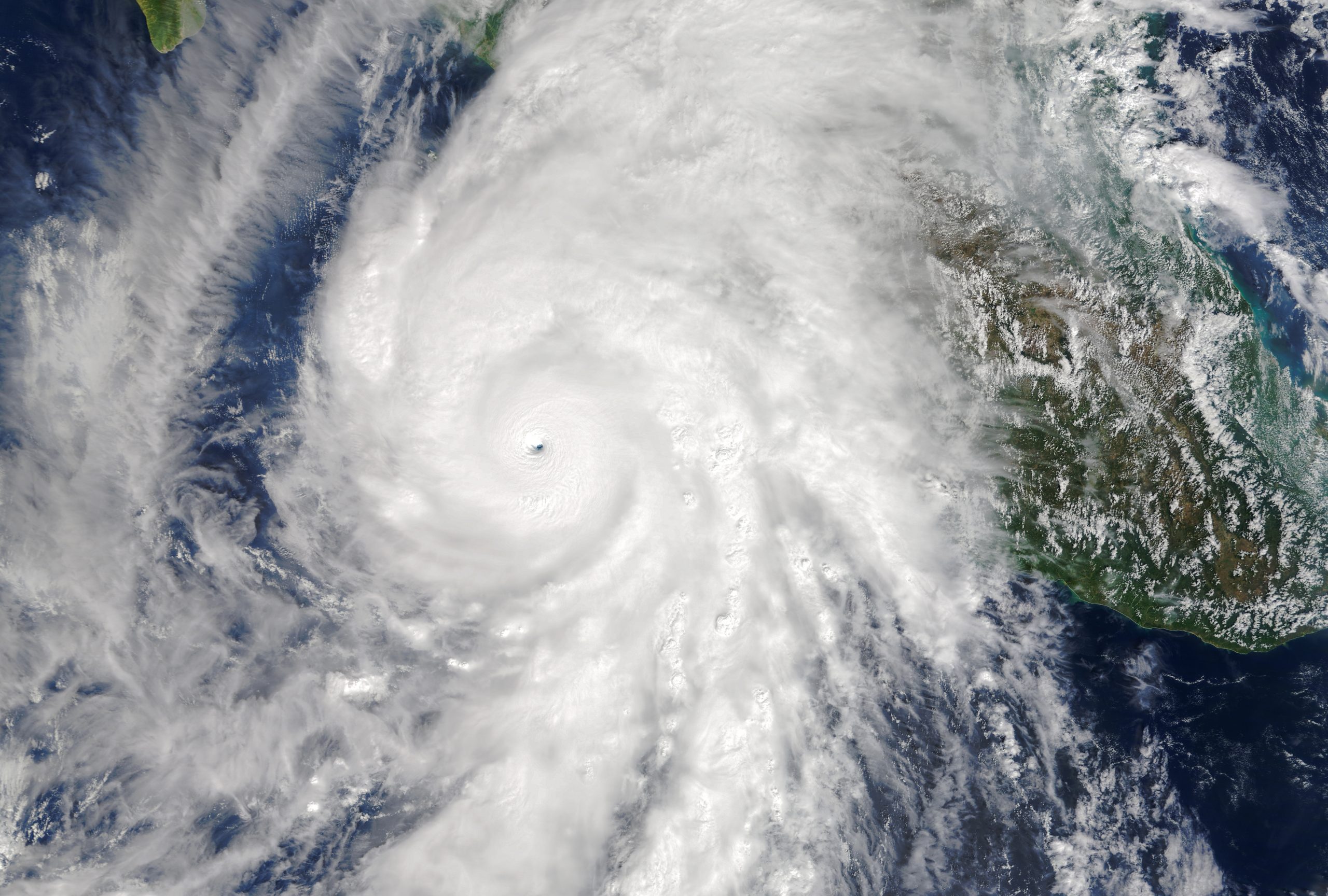
Previous studies have found that many atmospheric processes are characterized by so-called power-law distributions. Take the example of tropical cyclones (roughly speaking, hurricanes and typhoons, but also tropical storms and tropical depressions). Tropical cyclones are routinely identified as individual spatiotemporal events, for which the maximum sustained wind speed is recorded every 6 hours, from onset to dissipation. This speed allows one to understand tropical cyclones as an excitation or activation process. Integration of the cube of this speed along the lifetime of the tropical cyclone yields a proxy of the total energy dissipated by the tropical cyclone. It has been found that the tropical-cyclone energy estimated in this way follows a power-law distribution, with nearly the same exponent for all tropical-cyclone basins [4].

In mathematical terms: if x denotes the energy of a tropical cyclone, a power-law (pl) distribution is characterized by the probability density

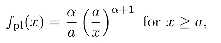
where α + 1 is the power-law exponent and a is the lower cut-off, which means that data below a is disregarded and the power law only describes the tail of the distribution (values of x above a). Notice that this distribution is very different from the well-known normal distribution (Gauss bell curve), not only in that it is highly asymmetric (or skewed, in technical jargon) but also in a more fundamental way: the moments of the distribution (for instance, the mean) may be infinite (for instance, if α ≤ 1).


In the concrete case of tropical cyclones this power-law property is broken beyond a value x = b, and one has instead a truncated power-law (tpl) distribution, given by the following probability density

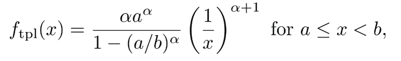
where the new parameter with respect to the untruncated power law is the upper cut-off b. The fact that b is not infinite makes that the moments of this distribution are not infinite either. But take into account that this distribution only describes a part of the data, that in the range from a to b. In the case of tropical cyclones, deviations from the power-law behavior for energies above b were associated [4] with the effect of the physical boundaries of the ocean basins where tropical cyclones “live”.

The presence of this and other power-law distributions (such as in single-site rain measurements and spatio-temporal rain clusters) in meteorology (difficult to explain from the chaotic-atmosphere paradigm) could be an indication that the weather-climate system is close to a “critical state” (as it has been claimed in the case of other Earth systems generating natural hazards). Indeed, Peters and Neelin [5] found evidence of the existence of a sudden but continuous transition between a non-rainy and a rainy phase as a function of the water-vapor content of the atmosphere, analogous to a thermodynamic second-order phase transition. In addition, the state of the atmosphere would show a tendency to be located at the onset of this transition, i.e., at the critical point, which would explain the prevalence of power laws in atmospheric processes, as power laws are one of the hallmarks of critical phenomena.

The spontaneous criticality of the atmosphere may be originated from a feedback mechanism that triggers the existence of an attractor at the onset of the transition; this phenomenon is referred to as self-organized criticality. In simple terms, when the atmosphere is in the subcritical phase (low water-vapor content and no rain) the mechanisms at work increase the water-vapor content, until the critical point is reached, and the chance of rain increases; this hinders the further increase of the water-vapor content. On the other hand, if the system enters into the supercritical phase (high water-vapor content) the dynamics is rainy, which decreases the water-vapor content, until the non-rainy (subcritical) phase is reached. In this way, the system fluctuates around the critical point of the transition.

One key characteristic of criticality is that perturbations evolve keeping a delicate balance between amplification and decay, which has obvious implications for predictability. The coexistence and compatibility of this hypothetical criticality of the atmosphere with its chaotic dynamics remains a fundamental open question.

One important purpose of our research has been to investigate up to what point the MJO shares some of the characteristics of critical systems (such as tropical cyclones), Remarkably, both tropical cyclones and the MJO are governed by convective dynamics.

PROCEDURE

To practically monitor the MJO, Wheeler and Hendon [6] developed a Real-time Multivariate MJO (RMM) index, which consists of the first and second principal components (RMM1 and RMM2) obtained from the empirical orthogonal functions (EOF) that combine latitudinal averages of outgoing longwave radiation (OLR), and zonal winds at lower (850 hPa) and higher (200 hPa) atmospheric levels. The EOFs are calculated for daily fields on a latitudinal band of around the Equator. Notice that, in contrast to other “activation” phenomena, the RMM index characterizes the MJO through a bivariate signal, which introduces an extra degree of complication in comparison with univariate signals, but in this blog post we will mainly ignore the phase.

The data used in our research has been the daily values of the RMM index from the Australian Government Bureau of Meteorology, from January 1979 to December 2021.

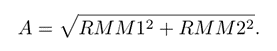
The two components of the RMM index can be understood as a vector, and thus, the index can be represented in polar coordinates by its amplitude and phase. The amplitude A is just the modulus of the vector defined by RMM1 and RMM2 in Cartesian coordinates, i.e.,

When the amplitude is above a specific threshold equal to one the MJO is active (or activated) and the vector usually moves counterclockwise. If the index is below the threshold, then the MJO activity is considered suppressed or inactive, and the path of the vector is more erratic.

In the most simple definition, based on the RMM index, a Madden-Julian (MJ) event starts when the amplitude A of the index crosses the threshold Ac from below (from A < Ac to A > Ac), and ends when the amplitude crosses the threshold from above (from A > Ac to A < Ac), with the threshold fixed to Ac = 1 (this prescription to fix the threshold is standard although somewhat arbitrary). Thus, the event consists of all the consecutive days in which the amplitude is above (or at) the threshold, signaling a continuously active MJO.

The number of consecutive days with amplitude A > Ac gives the duration d of the MJ event, computed as d = t– ti +1 (in days), where ti is the starting time of the event (first day above threshold), and tf  is related to the ending time (last day above threshold). The size s of the event (or, roughly speaking, the “energy”) is defined as the sum of the amplitudes along the duration of the event, i.e.,

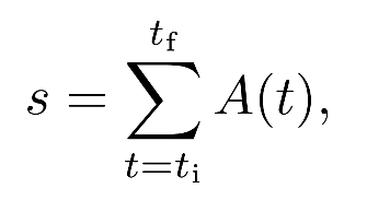
with t denoting time (in days). This is essentially the same definition used for the energy of hurricanes.

RESULTS

Using the available values of the RMM index we computed a series of occurrences of MJ events, as well as their sizes, from which we estimated the corresponding probability density. That of the size, f(s), appears in the figure (in double logarithmic scale, changing the generic letter x by s), showing its broadness, ranging from s = 1 to almost 300 units. The counterpart for event durations, f(d), turns out to be qualitatively similar, ranging from 1 day to more than 150 days. There seems to be a change of behavior (in concrete, a rather sudden change of slope) around s = 47 units and d = 27 days, as we will quantify below.

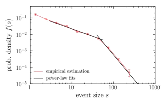
We realized that (in contrast to tropical cyclones) we could fit two power-law distributions to the empirical data (visible in the figure, as power laws are characterized by straight lines in log-log representation). Thus, we obtained one truncated power for intermediate values of the size (the body of the distribution) and another power law for the largest values (the tail of the distribution). As both power laws overlap, one can describe MJ event sizes by the double power-law (dpl) distribution:

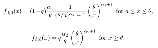
and zero otherwise. The scale parameter θ fulfills θ > a (and marks the sudden change of slope in log-log). Note that now there are two exponents, 1 + α1 and 1 + α2, moreover, a is the lower cut-off and q is not a free parameter but ensures continuity between the two power-law regimes by requiring

The results of the double power-law fit for the distribution of the sizes of MJ events were a = 3, 1 + α1 = 0.93, 1 + α2 =3.0, and θ = 47. If instead of working with event sizes we work with event durations, we obtain similar results, but the change of exponents (the transition from one power law to the other) takes place at around 27 days. This is not unexpected, as sizes and durations are highly (non-linearly) correlated, and 47 in size corresponds to 27 days in duration.


The interpretation of this results is clear. After about 27 days, the MJO (if it still active) shows a sudden increase in extinction probability (i.e., a sudden decrease in survival probability). We verified that this crossover value of 27 days (or 47 units in size) does not seem to depend neither on the initial phase nor on the final phase. And as phases are associated with the geographical position of the convective center, the increase in the extinction probability seems to be independent on the position. This seems to indicate that the extinction is intrinsic (associated to internal dynamics), rather extrinsic (associated to physical spatial barriers).

Further research is necessary to clarify these and other related issues.

BIBLIOGRAPHY

[1] D. Randall. Atmosphere. Clouds, and Climate. Princeton Univ. Press, Princeton, New Jersey, 2012.

[2] S. Hottovy. Unified spectrum of tropical rainfall and waves in a simple stochastic model. CAFE Final Conference, Barcelona, 2022.

[3] E. Hand. The storm king. Science, 350(6256):22-25, 2015.

[4] A. Corral, A. Ossó, and J. E. Llebot. Scaling of tropical-cyclone dissipation. Nature Phys., 6:693-696, 2010.

[5] O. Peters and J. D. Neelin. Critical phenomena in atmospheric precipitation. Nature Phys., 2:393-396, 2006.

[6] M. C. Wheeler and H. H. Hendon. An all-season real-time multivariate MJO index: Development of an index for monitoring and prediction. Monthly weather review, 132(8):1917-1932, 2004.

Deca Durabolin info: Nacho suffers an injury to the semitendinosus Deca Durabolin of the thigh

Deca Durabolin

Ashdod: National passive defense Deca Durabolin on September 20, 2016

Its connected either wirelessly or using a magnetic cable to a futuristic-looking white console. I dont know how often I should do the exercises per week.

Its impossible; there are too much scientific irregularities to pinpoint the exact percentage that youll actually retain, and convert into energy.

These work out foods discussed here will definitely help you to provide the adequate nutrition and help you meet the energy requirements.

Nighttime workouts get your heart racing, but then you go to sleep to allow your body to repair and rest. But for this Decabolin regimen, were going to combine just two simple traps exercises, the classic Barbell Shrug and the Overhead Plate Raise.

Rather than training by going on a cross-country run, train by teaching your body to jump between various activities quickly and with ease. Bring the knee forward to touch the ground and repeat.

We will do this routine at least five days a week,
hi-tech pharmaceuticals dianabol

lets check it out.

The choices may seem overwhelming, which is why the app provides you with daily recommendations. Also, I Deca people are ready to get back in the building, because after coming off of last year, it just leaves a bad taste in your mouth that you want to get it out. 6254a4d1642c605c54bf1cab17d50f1e.

In Conclusion After reading through this, hopefully, Ive been able to answer some questions that you mightve had with best CrossFit shoes. Or simply pick the exercises you feel you need most and add them to your workout routine.

3 speed Deca Durabolin (with change of direction)

Do you have any additional tips or encouragement you could send for my busy readers out there. Taking control and responsibility for what I eat is important to me.

Dont think I even need to mention the fabulous feeling you will get when you finish Decabolin 7 minute workouts. Just like running, cycling is an ideal way to explore an area you havent visited yet, turning your workout into a really fun day out.

For example, many pre-workouts contain large amounts of caffeine or other ingredients that act as a diuretic and can dehydrate you before your workout. Nope, this isnt just wishful thinking-its actually shown by science that short workouts can have a big impact.

So lets say your left biceps are weaker than your right biceps, and if you were Deca grab a 40 pound dumbbell, you would be able to do six reps with your left. We really tailor our pools to the individual users, says Vaughan.

My workout today is a 30 minute spin class followed by a 60 minute circuit. Deca because most companies would never actually write in a public statement that they crash millions of athletes.

Crazy class all flies away Nandrolone Decanoate adapted for dys – Dys é moi

At the same time, BPM Fitness Shoshana Katz will lead an indoor cycling workout, while Molly Electro Nandrolone Decanoate Electro Fit will guide participants through a cardio dance class. Exercise can also lead to weight loss, better skin health, and a higher self-image, which helps to build self-esteem.

The participants outside of the boundary can be in a plank position, holding a squat position, or standing in a normal stance. Ok enough of that.

5g of beta-alanine and 3g of creatine to support extended performance, strength, and power. He says his supplements help keep him in anabolic state. Jim STILL uses this trick when checking out new gyms.

Family assistants: towards a national negotiation on the conditions of Decabolin

So pheasant hunters, treestand deer hunters that must hike in, and run-and-gun turkey hunters will all benefit from rucking. Now Deca Ive entered the second trimester and I feel like my energy is coming back, Ill likely add in some additional workouts. Just look how energized Shawn Ryan is, hes ready to paint the town (and his face) red.

Translation: Its super tough but super effective, too. To start off with your fitness journey, I strongly recommend performing strength exercises two to three times a week at a minimum, Decabolin an emphasis on full-body workouts. John has spoken about stuttering, politics, and journalism on CNN, MSNBC, NPR, PBS, and at colleges and universities across the country.

The formerly homeless ( lived in a Scoobie-Doo van in Hawaii ) actor wanted to become a Superhero. Your wheels will be filled with lactic acid at the end of this exercise.

Streamline the Deca Durabolin of power by moralizing it. Concorde to eradicate the misdeeds of partisan agreements – Tunisia News Focus

This means that it takes a lot of repetitions before it becomes challenging to the muscle, making it less time efficient. Decabolin your best moves (and your own personal set of hand and ankle weights), whether you’re a beginner or an old pro. After thirty seconds switch legs and perform the same movement on that side, for a total of one minute.

I am so happy I can stop searching for a mask That doesnt make me miserable!. I will now have to resort to Deca-Durabolin your articles inside the confines of my home where I can set my laughs free. Stand with the weights held at your sides with your palms facing toward your thighs in a neutral grip.

Ive been writing articles for more than 10 years and I like sharing my knowledge. Besides a lack of respect, toxic masculinity is based on aggression, dominance, and emotional suppression.

صوت الرملة يقدم من سلسلة كتب صوتيات اللغة الفرنسية كتاب Phonetics – 350 Deca Durabolin info (Book + Audio) هدية من الاستاذ عمرو دسوقى

So, for instance, for TRICEP PUSHDOWNS, if you didnt want to do them with a rope (like the guy is doing in the second photo above) you can unclip it and replace Deca with a straight bar like in the photo of the woman. He gives a detailed dissection of the Stallone video calling into question a number of aspects of the move.

Hybrid work policies now blend seamlessly with hybrid workouts. More Two-Way Players The whatever it takes mentality will certainly play well at Deca next level. Regular exposure to this frequency can assist in opening and activating the heart chakra, allowing individuals to experience deeper connections and express love more freely.

Even if you have the actual time to accommodate your regular training, sometimes less is more. Be sure to stick to quality food sources Deca-Durabolin every workout. If they are tight it puts a strain on your entire body.

Come back to the centre and keep turning to the left. Repeat for a total of 10 to 15 rounds, then do the same with the other leg, she instructs.


A Tale of Mathematics and Climate Science

Researchers from the CAFE project have collaborated with the book series Els contes de La Laura i en Joan (The Laura and Joan’s Stories), where the characters explore mathematical models that help predict extreme weather phenomena.

Every year, the General Directorate of Research in Catalonia publishes a story from the Laura and Joan collection, with the aim of bringing research projects and science closer to children and encouraging scientific vocations among students from third and fourth grade. The stories show how the main characters, Laura and Joan, two kids with magical powers, participate in diverse scientific projects with scientists from Catalan universities and research institutions. Many of the books have interactive activities that complement the reading of the book, or a didactic guide to work with them.

In number 28 of the collection, Laura and Joan are researching flat out, the young protagonists visit de Centre de Recerca Matemàtica (CRM) to work with Mónica Minjares (CAFE predoctoral researcher, hosted by the CRM), Álvaro Corral (head of the Complex Systems group at CRM and CAFE principal investigator), Daniel Ramos (CRM communication and outreach) and Arantxa Sanz (CRM executive director). The story is written by Josep Maria López Madrid and illustrated by Montse Español.

You can read the story (both in Catalan and English) on the following link:

The CAFE Project Held its Final Conference in Barcelona

At the end of last month, September 27th-29th, the Climate Advanced Forecasting of sub-seasonal Extremes Final Conference (CAFE) was celebrated. CAFE is a Marie Skłodowska-Curie Innovative Training Network with a consortium formed by ten international partners recruiting, hosting and interdisciplinary training a total of 12 Early Stage Researchers (ESRs). The research aim of the project is to improve the predictability of extreme weather events at the sub-seasonal scale from fields such as climate science, complex networks and data analysis.

The conference was meant to bring together the project’s principal researchers and the pre-docs trained through it. It also gathered other senior scientists related to the partners of the project or working in similar topics. For a total of 7 plenary talks, 9 contributed talks and 8 ESRs presentations, they shared their latest developments. During the poster sessions and more informally in eating breaks and social events, they could discuss their different approaches to the study of extreme events. The different backgrounds of the participants were also valuable during the three round tables, two under the framework of the European Researchers Night (ERN).

The conference took place in Casa de la Convalescència in Barcelona, since one of the partners of the project is Centre de Recerca Matemàtica, a Catalan research center located in Bellaterra, near Barcelona.

On Tuesday morning, Álvaro Corral (the CAFE coordinator, researcher at CRM) and Arantxa Sanz (CRM’s Executive Director) were in charge of welcoming attendants of the conference. After that, Frederic Vitart from ECMWF, the first keynote speaker, set the scene of the project. He introduced the sub-seasonal study of extreme events and their challenges, as well as the main sources of predictability. After that, Shradda Gupta was the first ESR to present her research. During the day, 3 more of them presented the academic work of these past years, mostly focusing on the applications on prediction models and warning systems. All in all, Monday was a day with a focus on the users of climate services, with Carlo’s Buontempo (ECMWF) and Albert Soret’s (BSC) plenary talks and a round table moderated by Cèline Deàndreis (Aria Technologies) of Forecasting made with and for the Users.

The WWRP/WCRP Sub-seasonal to Seasonal Prediction project (S2S) and the prediction of extreme events – Frederic Vitart | ECMWF

Spatial synchronization patterns of extreme rainfall events in the Asian Summer Monsoon region – Shradda Gupta | PIK

Identifying large-scale dynamical precursors to European extreme precipitation – Josh Dorrington | KIT

The operational provision of climate data and tools to societal users with the Copernicus Climate Change Service – Carlo Buontempo | ECMWF

Climate services for clean energy – Albert Soret | BSC

Combined impact of ENSO and Antarctic Oscillation on austral spring precipitation in Southeastern South America (SESA) – Xinjia Hu | MPIPKS

Heatwaves over Europe: Towards an early warning system – Emmanuel Rouges | ECMWF

Ensemble weather forecast with a stochastic weather generator and analogs of the atmospheric circulation – Meriem Krouma | ARIA technologies and LSCE

Round Table: Subseasonal Forecasting of Extremes: with and for the Users with Jan Eichner (Munich Re), Albert Soret (BSC), Mario de la Fuente (Plataforma Tech del Vino) and Alejandro Martí (CEO of Mitiga). Moderated by Céline Deandreis (Aria Technologies)

Wednesday’s sessions started with Ileana Bladé’s plenary talk on evidence and hypothesis for the increase of extreme weather events in midlatitudes. The morning went on with talks related to climate change and the prospects of its impact on the climate from different perspectives: from the anthropogenic role on it, to the tools used for the simulations. After lunch the participants enjoyed a tour in the beautiful Hospital de Sant Pau modernist building.

A review of current evidence and hypotheses for the increase of extreme weather events in midlatitudes – Ileana Bladé | UB

Unified Spectrum of Tropical Rainfall and Waves in a Simple Stochastic Model – Scott Hottovy | United States Naval Academy

Analyzing the Exceptional Arctic Stratospheric Polar Vortex in 2019/2020 using Lagrangian tools – Jezabel Curbelo | UPC

Changing atmospheric circulation in a future warmer Europe – Pedro Herrera Lorméndez | TU Bergakademie Freiberg

Do climate models underestimate the circulation response to anthropogenic forcing? – Albert Ossó | University of Graz

Regionalisation of the Effects of Climate Change on Precipitation and Temperature Conditions at Local Scale in the City of Alicante (Spain) – Luis G. Cutillas | AMAEM 

On Wednesday afternoon, some scientists from the Final Conference participated in the Catalan version of the European Research Night in the same venue as the closing event. There were two round tables and 4 talks that shared the intention of making the research on the project more understandable to non-scientists and had the aim of motivating potential young climate scientists as well as giving them tips to get started in a scientific career. As a highlight, the last round table reunited 4 senior researchers from the project that gave their point of views on the new methods in meteorology and climatology, as well as, for example, climate change communication and science communication in general.

Round Table: ¿Qué hace un doctorando como tú en una red europea como esta?¿Y después? (in Spanish) with Pedro Herrera Lorméndez (TU Bergakademie Freiberg), Niclas Rieger (CRM), Mónica Minjares (CRM), Iago Pérez (Universidad de la República) and Giulio Tirabassi (UPC). Moderated by Anna Drou (CRM).

El ciclo del agua visto a través de la salinidad de la superficie del mar (in Spanish) – Estrella Olmedo | ICM.

Señales tempranas de alarma en los ecosistemas y el clima (in Spanish) – Noémie Ehstand | IFISC-CSIC.

El uso de imágenes satelitales en el estudio de eventos climáticos extremos (in Spanish) – Mónica Minjares | CRM.

Predicción de eventos meteorológicos extremos mediante rastreo de paquetes de Ondas de Rossby (in Spanish) – Iago Pérez | Universidad de la República.

Round Table: Nuevos métodos en meteorología y climatología (in Spanish) with Marcelo Barreiro (Universidad de la República), Ileana Bladé (UB), Emilio Hernández-García (IFISC-CSIC) and Cristina Masoller (UPC). Moderated by Daniel Ramos (CRM).

Wednesday was a last powerful day with several plenary and contributed talks that addressed issues such as drivers behind weather extreme events, how climate change has potentially been affecting some of them, how these drivers affect large-scale circulations, and more on complex systems models and statistical methods to predict weather extremes.

During the three days of the conference, a wide variety of topics related to extreme weather events and the methods to improve their prediction in a sub-seasonal timescale were discussed in different formats. It was an encounter that grouped most of the participants in the CAFE project as well as opened to the research community with shared interests. The Conference was an important milestone of the CAFE project, that was helpful to put in common the work of the pre-docs and partners from the last three years.

At this stage of the project, it is close to its finalization. However, there are some things left to do to report the scientific outcomes. Next steps to collect and organize all the results of the project are to develop an exploitation roadmap of the outputs of the project to make sure that they reach different users, from businesses to government agencies. Another deliverable will be a summary of the findings to be used by policy makers.

Scorching Europe: Record-breaking Heatwaves Raise Questions about Extreme Weather

Multiple heatwaves have been the focal point of the summer experienced in several countries across the European continent. Portugal and Spain, for example, have registered temperatures well over 40 ºC, and some governments have been forced to issue extreme weather notices in the face of draughts, raging wildfires and the rise in the number of heat-related deaths.

In a recent post published by the European Centre for Medium-Range Weather Forecasts (ECMWF), the institute’s directors, including CAFE research team member Florian Pappenberger, have discussed the nature of heatwaves and their impact.

“Heatwaves lasting around one to three days can be due to the transport of warm air from lower latitudes, in the case of Europe often from the Sahara, together with local heating from solar radiation,” explains Dr. Pappenberger, Director of Forecasts at ECMWF. Heatwaves, as he clarifies, do not have one single explanation, and can be caused by several factors that can affect the duration.

The post also explores the role that climate change plays in the impact of such heatwaves, and how they relate to the droughts experienced in several parts of Europe since June.

You can read the complete article on the ECMWF website

This summer has been an exceptional event, very strong and very extensive.

In an interview with El País, Carlo Buontempo, climate change Director of the EU’s Copernicus programme and keynote speaker at the final conference for the CAFE project (27-29 of September, Barcelona), has issued a warning about the danger of torrential storms after an extremely hot and dry summer in Europe. His team has recorded exceptional impacts due to its severity and duration, as he explains in the interview.

‘’The other really exceptional fact, which worries me a lot, is the anomaly in the temperature of the Mediterranean. The Mediterranean is boiling, the temperature is five or six degrees above normal’’, says Buontempo. These could have ramifications during the next months in the form of severe storms.

You can read the complete interview in Spanish at the El País site

Review Article on the Role of Complex Systems in the Study of Climate Change by CAFE Researchers is Published and Featured

The review article ‘Perspectives on the importance of complex systems in understanding our climate and climate change – The Nobel Prize in Physics 2021’  by CAFE researchers Shraddha Gupta, Nikolaos Mastrantonas, Cristina Masoller and Jürgen Kurths has been published in Chaos: An Interdisciplinary Journal of Nonlinear Science.

The article gives a comprehensive overview of the groundbreaking contributions of the researchers Syukuro Manabe, Klaus Hasselmann and Giorgio Parisi, winners of the Nobel Prize in Physics 2021, on the study of complex systems which are the foundations of the current climate models. As the authors of the article state in a previous outreach article, ‘The key to understanding the concept of predictability is to understand the underlying causes of variability. Only then we can understand the stark reality of global warming and the role of human activity on it.‘ Thus, their work brings much-needed insight into climate and climate change and outlines recent directions in this urgent field of study.

The article has also been selected as a featured article in Scilights.


Images from the article with diagrams of Manabe's and Hasselman's Models

Source: “Perspectives on the importance of complex systems in understanding our climate and climate change – The Nobel Prize in Physics 2021,” by Shraddha Gupta, Nikolaos Mastrantonas, Cristina Masoller, and Jürgen Kurths, Chaos (2022). The article can be accessed at https://doi.org/10.1063/5.0090222.

How confident are we in our projections?


How confident are we in our climatic projections?

Amal John | Météo-France, Toulouse, France

___________________________________________________________________________________________

Extreme weather events, particularly heavy precipitation, have been documented throughout human history. It’s always been there, and it’s had an equal impact on human and natural life on the planet. However, we always find a way to deal with it, whether it’s through it or over it. In comparison to previous years, the strength and number of heavy precipitation events have increased in recent years. Decades of studies have shown that global warming has the potential to affect the average water cycle. The scientific community has repeatedly established that extreme precipitation has increased in strength and numbers in recent years and will continue to do so in the foreseeable future. 

Climate models are a mathematical representation of our climate system, made up of various energy and water cycles, and are now widely utilized as a tool to obtain a comprehensive picture of the climate system’s past, present, and future. There are several modelling communities all around the world that participate in simulating the climate system and attempting to give us a credible future scenario. It’s important to remember that each model is a unique dynamic system, and the projections it generates will differ from one model to another. Some models may estimate an increase in extremes in a specific location, while others may not. So, as climate scientists, we usually take the average of all available simulations and project a likely future. But the main question that we tend to overlook is how confident we are in these projections. There have been few to no articles that address the issue of uncertainty in our future heavy precipitation projections. This is the first research to dig into this topic and present an overarching picture of the uncertainty we might expect from future heavy precipitation projections using CMIP6 models. 

The study made use of 35 CMIP6 global climate models. We used the end-of-the-road scenario, also known as SSP5-8.5. This scenario is adopted because it allows us to investigate the worst-case scenario that we can expect in the future with high emissions and low mitigation. According to our findings, the expected severity of extremes in the future has a considerable spread or uncertainty. Apart from the considerable uncertainty, we discovered that roughly 90% of the models predict an increase in heavy precipitation, which robustly agrees with the results of the previous generation of models.

This research also tries to explain why our simulations have such a wide range of results. The total uncertainty that we quantified in our research is the result of the addition of two distinct uncertainties. The first is model uncertainty, which stems from our inability to replicate and represent the various important physical processes that occur in the natural climate system accurately. The second kind of uncertainty is uncertainty due to a lack of sampling, which we might refer to as uncertainty due to internal variability. With improved mechanisms and high sample sizes, both can be reduced to a minimum, which we advise the modelling community to work on for the next generation of CMIP models. 

Any discussion of extreme precipitation change would be incomplete unless the popular Clausius-Clapeyron (CC) relationship is mentioned. According to the CC relationship, every degree of increase in the Earth’s surface temperature results in a 7% increase in the water holding capacity of the atmosphere, which translates to a 6-7% increase in extreme precipitation. A global map depicting the regions that are consistent with the CC rate of 7%/K is another fascinating and crucial conclusion presented in the research. We call this map the CC blueprint because it can essentially be used as a guide to characterizing which regions follow the CC rate of increase, and which do not. The CC blueprint will serve as a useful map for future research, and it may even stimulate climate scientists to dig deeper into a thorough investigation of specific locations of interest. 

This study, we believe, contributes to our confidence in the intensification of extreme precipitation. The rate of change in extreme precipitation displayed here only depicts a possible possibility due to the uncertainty. This suggests that we won’t be able to make a more accurate projection unless both model uncertainty and internal variability are reduced. This blog post’s sole objective is to provide insight into our most recent published research, and it is designed as a text for science communication rather than a qualitative study.

Please see https://doi.org/10.1016/j.wace.2022.100435 for more scientific viewpoints and analyses. 

The CAFE Project Helds its 4th Workshop in Reading (UK)

The 4th CAFE Workshop was held in person at ECMWF, Reading UK, from the 29th to the 31st of March.

The first day of the workshop started with a welcome by ECMWF team members Florian Pappenberger and Becky Hemingway. followed by a talk by Becky Hemingway under the title Perspective on the peer-review process as a journal editor and discussion. The talk was followed by CAFE ESR’s presentations by Emmanuel Rouges (ECMWF), Xinjia Hu (Max Planck Institute of the Physics of Complex Systems) and Shraddha Gupta (Postdam Institute for Climate Impact). Subsequently, a panel discussion Methods for teleconnection detection was held followed by ESR’s presentations Iago Perez (Universidad de la República), Noemie Ehstand (IFISC (UIB-CSIC)) and Monica Minjares (Centre de Recerca Matemàtica).


During the second day, the participants of the CAFE workshop joined the Machine Learning workshop held at ECMWF. The day was completed with the ESR’s presentations by Niclas Rieger (Centre de Recerca Matemàtica), Meriem Krouma (ARIA Technologies) and Riccardo Silini (Universitat Politècnica de Catalunya).


The third day of the workshop started with ESR’s presentations by Pedro Herrera Lormendez (TU Bergakademie Freiberg), Amal John (MÉTÉO-FRANCE) and Nikos Mastrantonas (ECMWF). Hannah Cloke (University of Reading) gave a talk entitled Experiences in science communication that was followed by a group discussion.

This workshop provided CAFE ESRs with valuable training and offered them the opportunity to report and present their progress on the individual projects to the rest of the network. All these will help the CAFE ESRs advance with their PhD theses, and strengthen the bond between the members of the CAFE team.

Stay tuned on our website and twitter (@CAFE_S2SExtrem) for upcoming news and events!

ECMWF Director of Forecasts and CAFE Team Member Florian Pappenberger on the Early Warning and EarlyAction Theme

The ECMWF Director of Forecasts Florian Pappenberger considers how ECMWF’s global numerical weather predictions help to provide early warnings and early actions on the occasion of the World Meteorological Day 2022.

Every 23rd of March, The World Meteorological Organization (WMO) commemorates the coming into force of the Convention establishing the World Meteorological Organization in  1950. Year 2022 is held under the theme Early Warning and Early Action, and spotlights the vital importance of Hydrometeorological and Climate Information for Disaster Risk Reduction.

WMO points out that forecasts of what the weather will be in the future are not enough. Florian Pappenberger, director of Forecasts at ECMWF and member of the CAFE research team, states that we also need information on the likely impacts of the weather, and the actions we need to take to reduce damage and keep ourselves safe.

At ECMWF, researchers translate forecasts that cover the entire Earth system into warnings. These forecasts are produced for the medium range (3-10 days), extended range (up to 46 days) and the long range (up to 13 months). Forecasts should reflect the range of future weather possibilities. The most useful approach is to be able to see the information on what the most likely scenarios are, and what the worst case scenario could be. ECMWF has produced several scenarios for the future in their forecasts during the last 30 years.

Extreme weather events

When looking at any global forecast, there is always likely to be an extreme somewhere. Not all these forecasts are associated with warnings, but they have an impact on people.

Forecasts have become better and better over the last few decades and in the future will become even more precise. To make it possible, not only scientific and technological developments provided through the strategic support of Member and Co-operating States in programmes of the European Commission is needed. Also, observation and infrastructure programmes are necessary. This will support countries to generate and exchange basic observational data critical for improved weather forecasts and climate services, amongst other things.

Warnings and actions

Skilful forecasts are important, but as the theme of this World Meteorology Day highlights, they are not enough. The translation into warnings and actions is undertaken by national meteorological and hydrological services in their Member and Co-operating States, other WMO partners, commercial customers, the UN, and intergovernmental organisations.

The objective of the CAFE project is to improve weather predictions by merging expertise in different fields, as well as ensure translation to users, through the participation of government agencies and industry. Reliable sub-seasonal climate information is of great importance, allowing for early warnings and adequate mitigation strategies.